
Drone Aerial Photography
Netix Solutions is proud to offer professional drone aerial photography services. Get aerial images and video from a professional FAA certified drone pilot at a fraction of the cost and time. We are licensed and insured for all of our services.
Netix Solutions offers the latest drone technology to capture amazing video and photos from any angle you desire. We have FAA licensed and insured pilots who will bring this technology to your doorstep. Plus, you'll receive a high quality album of all the footage and photos taken at your event or location.
Imagine being able to see your project or event from a whole new perspective. With our top of the line drone technology, you can get creative aerial shots that will leave your audience in awe. Let Netix Solutions help you capture memories that will last a lifetime.


FAA CERTIFIED
UNMANNED AIRCRAFT SYSTEM
DRONE PILOTS


Showcase Your Property
Based out of Wesley Chapel, FL and founded in 2008 our goal is to set the standard for all residential video marketing and media by turning your property into a beautiful work of art. Allowing your prospects to see the true beauty in your community. We take your property to a new level using the latest drone technologies show off your amenities and take a look inside your complex. We work hand in hand to create the ideal media for your property and marketing strategy.
We are fully Certified Licensed and Insured

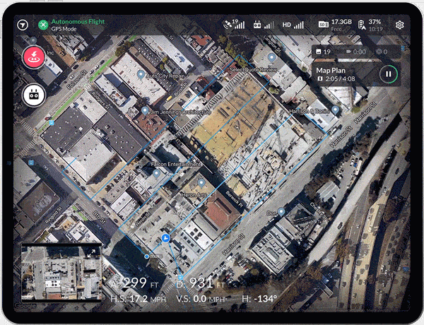
Harness the Power of Advanced Drone Mapping Technology
Using our state of the art drones and software we can 3D map your home, business, site, etc. You can receive the raw image files to further your project or a custom video can be made to show off your assets.
We can also complete the same models over and over again to show progress on a project!
Unlimited Possibilities
Unlimited Solutions
Save time, improve communication, and reduce cost by using drone data to perform surveys, conduct inspections, and document every job site. Using Netix Solutions drone data software, customers gain the confidence to take their business to new heights. Through interactive digital maps and in-depth analysis, projects run on time, on budget, and safely.